Data Simulation Tool
A simulation tool that models how disruptions on inland waterways ripple through connected road, rail and port networks.
Inland waterways carry about 20% of America’s coal, 22% of U.S. petroleum products and 60% of farm exports. This study collects data on natural extreme events that affect the waterways, predicts future events with a spatio-temporal statistical model, and simulates how those disruptions affect the interconnected transportation system.
A case study of the Mississippi River and the McClellan–Kerr Arkansas River Navigation System (MKARNS) shows how the tool supports interdependence modeling and decision making. The methods center on inland waterways but apply to local, regional and national infrastructure.
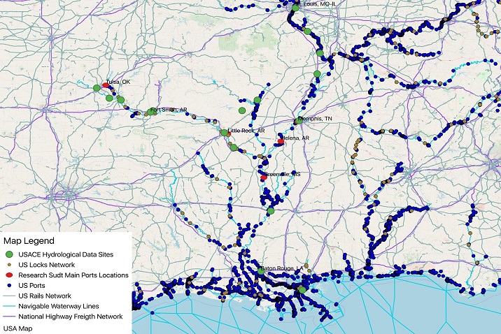
Highway, rail and waterway networks, locks and ports across the study region. Select the map to enlarge.
Map: Azucena, Alkhaleel, Liao and Nachtmann, U of A Industrial Engineering; data from USACE and USGS.
Data in the Simulation
Simulated data are derived from actual data on interdependent critical infrastructures, including:
Transportation Networks
Inland waterway and ground transportation networks, such as road type and road capacity.
Locks & Dams
Locations of locks and dams along the river systems.
Ports & Commodities
Locations of major ports and their top commodities.
Hydrological Observations
Historical water depth, waterway changes and normal inland water transport capacity at ports and locks.
Vessels & Barges
Major cargo vessel and barge types, classified by capacity and typical transport speed.
Weather
Weather data covering the study regions.
Request the Tool
Complete the request form to receive the simulation tool, its user manual and general instructions for its use.
Learn more in the study’s paper, “Hybrid Simulation to Support Interdependence Modeling of a Multimodal Transportation Network” (Azucena, Alkhaleel, Liao and Nachtmann, 2020).
Data Simulation Request FormContact Us
Mack-Blackwell Transportation Center, University of Arkansas
4190 Bell Engineering Center, Fayetteville, AR 72701
479-575-6021 · mbtc@uark.edu